Knowledge journal / Edition 2 / 2015
Willows for less expensive and more beautiful dikes
Traditionally willow riverbanks form a characteristic part of the river and fresh water tidal landscape. The creation of intertidal dikes can break waves significantly and reduce the dike height required. But what exactly is the effect of a willow river bank and how could this concept be consistent with the new way of dike assessment in the Netherlands?
Around Fort Steurgat near Werkendam a new primary flood defence was planned. The flood defence was needed because of the flooding of the Noordwaard, an action resulting from the programme Ruimte voor de Rivier (Room for the River) that was initiated in to limit flood of large rivers and to enhance the environment’s value.
The Werkendam flood defence is built in combination with the planting of a river bank (willows) at the riverside according to the concept Building with Nature; using natural processes to add to water safety. At the design of the ‘willow bank dike’ it was presumed that in case of extreme high water levels incoming waves breaks at the riverbank, so the crest of the dike can be less high.
The riverbank dike at Fort Steurgat is a primary flood defence, periodically tested on flood risk. The current legal assessment instrument (WTI 2006) however does not provide in a testing method for such a riverbank dike. This article describes the way in which an assessment for this river bank dike was established and how it can be generalised, taking into account the specific characteristics and the wave reducing effect of the willows on the riverbank.
Exploratory investigation
In 2009 Deltares survey (see bibliography) investigated the possibilities of alternative dike designs, where breakwater vegetation is an integral part of flood defence. An integrated dike design was introduced, assuming that an intertidal area reduces 60 per cent of the incoming wave height (breakwater).
Apart from the fact that in that case a lower flood defence would suffice, neither a traditional hard dike revetment would be necessary, but a less expensive clay revetment with a grass cover would be adequate. That can make a large difference in the construction costs. Furthermore a willow bank dike has more nature value and can be fitted better in the polder landscape if there is enough space before the flood defence.
Testing model
The assessment method that was specifically developed for this purpose is described in the publication Assessment method willow bank dike Fort Steurgat (see bibliography). It concerns a tailor made assessment method, specifically applying to this location. Being ‘tailor made’ this method is part of the new Legal Test Instrument (WTI). Further development however is necessary to make the assessment method less complicated and generally applicable as part of the standard instrument.
The assessment method that was designed for riverbank dikes consists of an assessment of the wave reduction of the willow bank and an assessment of the crest height of the dike. In this case one is free to choose any testing sequence. For instance, when the crest of the dike – without taking the willow bank into consideration – suffices, water safety is guaranteed with regard to this aspect and assessment of the riverbank is not necessary.
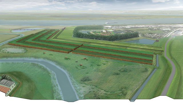 Artist impression of a willow bank in front of a flood defence
Source: Robbert de Koning landscape architect BNT
The assessment scheme consists of several steps, from rough to fine. At first a visual inspection is the base for determination of amount of the surface for a willow bank. Then complementary it is verified whether the willows are subject to erosion, disease or damage. Subsequently a calculation model verifies whether the assumption for the minimal reduction of the wave height in the design can be maintained.
When the verification of the calculation model indicates that the reduction of the wave height is minimally 60 per cent the assessment can be continued. In that case field measurements must be conclusive on the height and the density of the willow bank and the number of rootstocks (under stems that stay erect when the branches are cut at the level of half a meter). The vegetation volume in the willow bank indicates the density of the willows and consists of the volume of all rootstocks and branches in the willow bank between the soil surface and the assessment water level.
Height of the willows
For sufficient resistance to the incoming waves the willow branches must be higher than the normative high water level in connection to the dike concerned. At determining this water level the effect of the sea-level rise, the increase of the river discharge and such are taking into account. For the determination of the density sample survey sections in parts of 2 by 2 metres rootstocks are counted and their diameter is measured. Per survey section also at three willows the branches diameters are measured. The results are compared to the design data.
Subsequently starting points and hydraulic boundary conditions are assessed. This implies a comparison of design and assessment framework conditions and the differences in geometrical characteristics of the willow bank between the design and the actual situation.
It must be assessed whether the high water levels used in the design are equal to those applicable during the assessment. Besides, the crest height and effective width of the willow bank should not be smaller than the values used in the design. The effective width of the intertidal area is determined by measuring the width without the paths and corridors in the intertidal area.
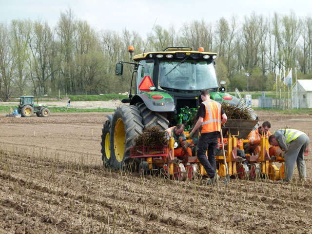 The planting of willow cuttings at the Fort Steurgat dike
At the dike around Fort Steurgat one of the most complicating starting points is that the willows cannot become too high and obstruct the view of the Fort Steurgat residents. Willows however grow very fast; so cutting right above the stove knot must take place once every two years. To prevent removing too much of the willow bank due to cutting, its construction is double in strips. Yearly half of the strips are cut to ensure a minimal amount of willow bank. Cutting at the end of the winter guarantees sufficient willow bank at the start of the following storm season.
Broader application
What are the broader possibilities for intertidal area dikes? In 2017 the Netherlands will adopt new safety standards, which are not based on the probability of a certain water level, but on the probability of flood risk of a certain area. As a result of the new standards more dikes will require reinforcement. In the context of a quick scan it was considered where in the flood plains of the river area vegetation (like willows) can have a positive effect on water safety. Eighteen locations were appointed for useful further investigation of possibilities.
In order of the Water board Rivierenland Deltares calculated how much wave reduction is realised by actual vegetation at the toe of the dike under normative conditions. These are the water levels and waves corresponding to the safety standard of the dike body. This study was carried out for the flood plain of the Rijswaard alongside the river Waal in western Noord-Brabant. Also for this area a reduction of wave height of 60 per cent seems to be feasible, with additionally a reduction of the wave period (important with regard to the wave run up against the dike). It will lead to a substantial decrease of the wave overtopping.
The design at Fort Steurgat was based on a reduction of 60 per cent wave height.
However a larger reduction is expected to be possible, but that has to be indicated by a computer model made available for this purpose. The current design uses the vegetation module in SWAN-MOD, version 40.55. This vegetation module however has not yet been calibrated or validated.
Another point of attention is that in view of the program Ruimte voor de Rivier (Room for the river) it was stated that vegetation should not limit the drainage capacity of a river. The programme Stroomlijn (Stream line) limits the acreage vegetation on flood plains.
Recent survey has shown that on many locations current vegetation in the flood plains is not limiting the drainage capacity of the river. Vegetation by breaking waves possibly having a positive contribution to water safety will have to be balanced to a possible negative contribution to water level increase. This also applies to willow intertidal areas.
On balance
Application of willow bank dikes can ascertain that where wave attack is concerned the crest height of a flood defence should be not at all or considerably less raised.
Consequently the available space of the dike and expenses for dike reinforcement are reduced. On the other hand, for the willow bank space must be available and the contribution of a living and dynamic part of the safety solution in the long term must be quantified and guaranteed. Adequate management and maintenance must secure this. A survey for the Water board Rivierenland has indicated that other vegetation types, that are also valuable elements in the river environment, can also add to wave height reduction.
Johan van der Meulen
(Waterboard Rivierenland)
Mindert de Vries
(Deltares)
Marike Olieman
(Department of Waterways and Public Works WVL)
Hans Venema
(Deltares)
Harry Schelfhout
(Deltares)
Summary
Around Fort Steurgat a new dike was built with a (willow) bank area at the meadows. Innovative here is that the intertidal area is built to break the wave attack in extreme circumstances, so that dike design can be less high and less expensive.
From field measurements and calculations using a wave model a relation has been determined between the density of the willow bank and the attenuation of the incoming waves. The willow banks established a wave height reduction of minimally 60 per cent allowing the crest of the dike to be build 60 centimetres lower. To test the wave breaking function of the willow bank a testing method and monitoring plan have been developed. Advanced management and maintenance must monitor the condition of the willow bank. Shallow, vegetated meadows, such as willow banks, are expected to limit the space and expenses of future dike reinforcement. Embedding of the rural design and testing instrument is necessary to achieve that.
Literature
Design green wave breaking dike Fort Steurgat at Werkendam, survey (in Dutch), Deltares, Z4832.00, April 2009.
Testing method Fort Steurgat, Deltares, 1206002-000-GEO-0023, April 2014 (in Dutch).
Quick scan Wave breaking vegetation at Stroomlijn, Deltares, 1206002-000-GEO-0005, October 2012.
Quantifying the effect of wave breaking by vegetation on flood plains, June 2015, Deltares, 1220539-000-ZWS-0006.
Auteurs

Johan van der Meulen
(Waterboard Rivierenland)

Mindert de Vries
(Deltares)

Marike Olieman
(Department of Waterways and Public Works WVL)

Hans Venema
(Deltares)

Harry Schelfhout
(Deltares)